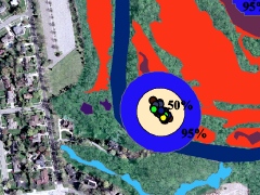
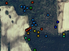
Delineation and Mapping
HRM has a long history of habitat mapping. A critical part of any wildlife related project is a firm understanding of the landscape and ecological communities contained within it. We provide our clients with a suite of available mapping options. We put our years of experience in GIS, GPS, and aerial photograph interpretation to work in creating exceptional maps that accurately and clearly describe what is present on our client’s property. We utilize top-of-the-line mapping software and equipment to best serve our client’s needs. We are experienced with a variety of mapping technologies and use submeter-accurate GPS equipment with GIS software on multiple platforms. These include ArcView 3.x, ArcMap 9x & 10x, and ArcPro.
- Habitat Mapping, Evaluation, and Suitability Modeling
- Wetland Mapping and Assessment
- Landscape and Ecological Community Classification and Mapping
- Land Use Analysis and Vegetative Cover Types
- Landscape Fragmentation Analysis
- Impervious Cover Analysis
- Wellhead Protection Areas
- Tree/Forest Preservation Mapping